TAKE ACTION
RESPOND TO THE CONSULTATION - Your Voice Counts - THERE'S STILL TIME!
Now that the Environment Agency has submitted the Oxford Flood Alleviation Scheme planning application there are several ways to respond:
Comment on the Planning Application
THERE 'S STILL TIME TO RESPOND! SAY CLEARLY WHETHER YOU OBJECT OR SUPPORT.
SEND YOUR COMMENTS DIRECT TO:
Matthew.Case@Oxfordshire.gov.uk
Sign the Petition to Save Hinksey Meadows and ask Michael Gove to call in the application so it can be examined by a Planning Inspector in a Public Inquiry.
For guidance, here are some objections from noted experts. Dr Riki Therivel is a sustainability consultant. Professor Veronica Strang is an international expert on water issues and river management.
Comment on the Planning Application - Deadline 9th May!
How to read the planning application
The full application for the Oxford Flood Alleviation Scheme (OFAS) is at
https://myeplanning.oxfordshire.gov.uk/Planning/Display/MW.0027/22#undefined. Scroll to the bottom of the page, click ‘accept’, and on the next page click ‘documents’. There are 302 documents, some of which are more important than others, which is why this little guide has been put together.
Overview: A general scheme overview shows the components of the scheme in operation. More detailed diagrams of the 3-5 year scheme construction are at:
A set of maps show the extent of flooding with and without the OFAS under various scenarios.
The environmental statement (ES) and its non-technical summary are the main reports that discuss the impacts of the scheme. The ES includes some visualisations of what the completed scheme will look like.
Appendix Q of the ES shows that a ‘no channel’ alternative would have almost the same flood protection as the proposed OFAS scheme, and have a better benefit:cost ratio. The channel component of the OFAS scheme has by far the most environmental, social and economic costs, but provides only about a 5% reduction in flood risk.
Traffic: Table 11.3 of the ES shows that construction of the OFAS would involve almost 200 HGV movements per dayfor 3-5 years:
Into/out of the Botley Road at the Seacourt Park & Ride: 36/day
Into/out of South Hinksey at the north end of the village: 144/day
Into/out of Abingdon Road: 14/day
Page 244 of the environmental statement notes that a 40mph speed limit on the A34 would be requested between the Botley Interchange and a point south of South Hinksey. To prevent completely unacceptable queues at the Hinksey Hill interchange, Sec. 4.2.4 of the transport assessment proposes that a 20mph temporary carriageway will link Kennington Road and Old Abingdon Road.
Biodiversity: Table 8.8 of the ES explains that the OFAS would result in the loss of 3.1ha of Hinksey Meadow, of which 1.33ha is rare MG4a grassland (about 1% of all the remaining MG4a grassland in England and Wales). Appendix C-5 of the ES explains that the OFAS would probably dry out the rest of Hinksey Meadow to the point where the plants that make it a rare MG4a grassland would no longer be able to survive. In other words, the OFAS would indirectly affect the whole of Hinksey Meadow.
The OFAS proposes to create new sites of MG4 grassland, but the ES notes that “Habitat creation and translocation are not a substitute for in situ conservation of this kind of habitats, the latter approach always being preferable where possible”.
Table 8.8 of the ES also states that most of the pond at Kennington Pit Local Wildlife Site will disappear. Table 7.4 of the ES explains that most of Kendall Copse will be lost. The scheme would also affect otters, bats, water voles and other species in the area.
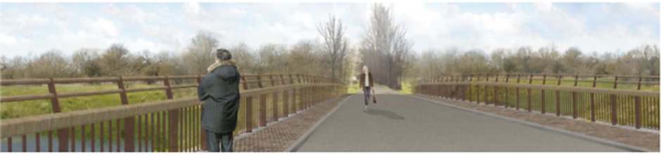
Visual: The ES shows few photomontages of what the scheme will look like. Figure 7.12 shows the loss of trees at the Seacourt Nature Reserve. Figure 7.21 shows that the proposed bridge at Willow Walk would be enormously wide and paved, more like an airport runway than a pedestrian and cycle track. Figure 7.35 shows what the Devil’s Backbone would look like.
Cumulative: Cumulative impacts are impacts that individually are minor but together are major. The OFAS would have some significant cumulative impacts:
Loss of 2000 trees in the area (Table 7.5 of the ES)
South Hinksey is encircled by construction compounds and access routes for 3-5 years
Loss of recreational access to much of the area during construction
How to comment on the planning application
You can fill in the form at https://myeplanning.oxfordshire.gov.uk/Planning/Display/MW.0027/22#undefined and/or send your comments to (may as well send to all three):
Please be clear about whether you are opposing or supporting the OFAS. If you support the idea of flood alleviation but oppose this scheme (e.g. because its impacts would be too severe), please oppose this scheme but write that! Points that are likely to have particular resonance[1] are:
Harm to the Hinksey Meadow and Kennington Pit Local Wildlife Sites.
Unacceptable impacts on traffic on the A34, including a 40mph speed restriction and uncertainty about the effectiveness of a temporary bridge at Kennington
Harm to people’s health, particularly in South Hinksey, from noise, vibration, dust and air pollution.
The fact that the proposed scheme does not follow the ‘mitigation hierarchy’ of first avoiding impacts (e.g. no channel through Hinksey Meadow), then mitigating (narrower channel) and then compensating (trying to create new sites). A ‘no channel’ option would avoid most of the OFAS impacts.
[1] These points relate to the planning framework that Oxfordshire County Council and the Vale of White Horse District Council must follow, i.e. the Oxfordshire Minerals and Waste Local Plan, the Vale of White Horse Local Plan, and the National Planning Policy Framework
For more information visit https://www.onlyoneoxford.org/save-hinksey-meadow
Oxford Flood Alleviation Scheme
green - new 5 k channel
light blue - new stage 1 channel
medium blue lines - existing water courses
brown - maintenance roads
dark blue -created wetland features
yellow areas - mitigation MG4 grassland (on existing semi-improved grassland)
purple hatch - mitigation woodland
PLEASE SIGN THE PETITION to ask Michael Gove
- to launch a public inquiry to scrap the channel and save Oxford’s iconic floodplain meadows and to adopt a more effective, climate friendly whole river flood scheme.
- re-designate Hinksey Meadow as a Site of Special Scientific Interest.
Why we need a better flood scheme
Save Hinksey Meadow and Scrap the Channel
Oxford desperately needs an effective flood scheme but a destructive and ineffective 3 mile flood channel through the rare Hinksey Meadows would wreck the local environment and could cause biodiversity collapse in Oxford’s wildlife corridor and release a huge amount of carbon from excavation and construction. 85% of the scheme for embankments and bunds together with existing measures, provides most of the protection. It makes more sense to adopt the scheme without the channel: we’d get most of the benefits with far fewer costs and minimal disruption.
Hinksey Meadow
A Stonehenge of Floodplain Grassland - Why it is a national treasure
A nationally important, ecologically rich floodplain, Hinksey Meadow contains rare MG4a grassland. Only 4 square miles of this habitat is left in the UK (an area the size of Heathrow Airport). Already designated a Local Wildlife Site, Hinksey Meadow should by government criteria be classified as a Site of Special Scientific Interest.
The channel would dig up 3 acres of Hinksey Meadow but the whole meadow is threatened due to the hydrological changes that this channel would bring.
This immensely biodiverse habitat is home to rare plants such as fritillaries and the red listed creeping marshwort. The whole plant community of 26 species growing together is important. It is one of the last remaining sites in the UK of particularly species-rich MG4a floodplain meadow vegetation. It is an historic meadow and the 9th largest MG4a in the UK. But it is also invaluable in other ways, holding and filtering floodwater, and storing as much carbon as peat bogs. Digging up this carbon rich meadow will release tons of carbon that have been stored for over 1000 years, at a time when we are urgently working to reduce our carbon footprint.
"If it were an animal or a building, bus-loads of tourists would be coming to see the 'last of its kind in the wild'. The chances of replacing this unique habitat and as important a part of our cultural heritage as the Ashmolean and Radcliffe Camera, are very slim. There is no scientific evidence for the success of translocation of Floodplain Meadows."
Catriona Bass - Long Mead Biodiversity Research Project and Expert on Wildflower Meadow Restoration
 |  |  |
|---|---|---|
 |  |  |
In addition to the loss of Hinksey Meadow - Catastrophic consequences to wildlife corridor
OFAS would destroy 250 acres of agricultural land, 2000+ trees, miles of biodiverse hedgerows and wildlife corridors and habitat for badgers, otters, kingfishers and bats, at a time of ecological emergency and food insecurity.
The EA make unachievable promises about ecological and tree-planting mitigation much of which is offsite and/or will take decades to grow to replacement value.
The amount of accessible public space would be reduced by 20 acres
Construction and excavation of 455 000 m3 (cubic metres = approx. 700,000 tons) soil and gravel would bring additional pollution, noise and congestion for 3 - 5 yrs
Loss of Iconic Landscape
The iconic landscape painted by JMW Turner and celebrated by Matthew Arnold would be lost. Willow Walk and Hinksey Village are famous for John Ruskin and the Diggers who included Oscar Wilde and Hardwicke Drummond Rawnsley, co-founder of the National Trust. So, it is arguably the birthplace of the modern conservation movement.

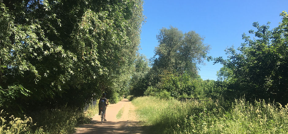
Willow Walk - Loss of veteran trees
Willow Walk is also known as Ruskin's Ride after the famous Victorian polymath and early conservationist, John Ruskin who was Slade Professor of Art at the end of the 19th Century. Recent archeological excavations found stone flints from hunter-gatherers, and bronze and Iron Age settlements.
Before
After
This destruction does not make any economic sense
At a cost of £23 million, the channel is the most expensive and destructive element of this scheme but provides only 5% of the reduction in flood risk. The EA's own calculations show that the channel only reduces the risk to just 54 houses . These homes could be protected by more environmentally friendly and effective methods.
The channel is billed as a 100-year scheme, but the maintenance budget is only for 10-15 years. It would silt up without maintenance.
There is a better alternative to protect Oxford from the flooding risks of climate change
1. Scrap the flawed channel component of OFAS
2. Look at whole river system and natural flooding solutions to capture water in land upstream by restoring flood meadows, growing food regeneratively and planting new woodland.
3. Stop building on floodplains and prevent run off from overdevelopment elsewhere
Take Action
Complete the consultation (see information below)
Information to help complete the consultation
Objections are best framed according to national policies
Policy 6: Building a strong, competitive economy
The channel is a waste of public money costing £23 million for minimal protection.
Policy 14: Meeting the Challenge of Climate Change, Flooding and Coastal Change
The channel is not effective enough to protect Oxford from these challenges.
Policy 15: Conserving and Enhancing the Natural Environment
The channel causes unnecessary environmental destruction of rare meadow, hedgerows and habitat for protected species; otters, kingfisher and badgers.
Additional Objections
A comprehensive list of national policies that OFAS fails to meet
Fails Policy 8 . Promoting health and safe communities
While it claims to create access to high quality open spaces it actually restricts community access to the principal green spaces of West Oxford for 3-5+ years plus and reduces their extent thenceforth, giving less access to walking and cycling. 8 hectares in existing public space is lost.
Relies on contractors to control pollution and hazards during construction. Adds to the traffic congestion on local roads which already suffer from excess vehicles and pollution.
Much of Seacourt Nature Reserve lost as a public amenity.
Fails policy 9. Promoting sustainable transport
The EA OFAS Planning Statement claims ‘There will be no transport impact from the proposals during operation’.
As they are planning 111 vehicle movements per day for 15 months of the three (+?) years of gravel digging this is a very dubious claim and presumable can only be ‘true’ because of their form of words, which must mean national level transport impact. They admit to ‘some impact on the local road network during construction from vehicles travelling to and from the site’ but claims that this is dealt with because they’ve submitted an outline Construction Traffic Management Plan are unjustified.
The scheme’s traffic will have a major impact for local residents and anyone travelling through Oxford's roa.
The main workyard of the scheme is situated right up against South Hinksey village, necessitating noise and disruption (which the EA says it will try to control, but cannot in the light of the number of vehicle movements and the scale of the digging out of the ancient floodplain meadows and earthwork construction).
Gravel and soil that is not used in the scheme, will need to be trucked around on the new access roads to be taken out to the A34 where it will add to the already extreme congestion there.
-114 HGV movements per day from South Hinksey on and off the congested A34 near the Hinksey Hill Interchange (the A34 is a route of more than local significance)
-35 HGV movements per day from Seacourt Park and Ride onto the congested Botley Road plus contractors’ vehicles from the contruction area in the Seacourt Nature Road
- movement of construction vehicles across the busy Abingdon Road on the proposed haulage routes to the worksite on the southern border of Hinksey Park, ultimately causing futher congestion on the A34
-congestion at the south end of the scheme where the main construction access for the Hinksey Stream channel is via the Redbridge Park and Ride
Fails policy 12. Achieving well-designed places
Despite EA claims that since they’re not building a housing estate, they are preserving green belt and open spaces and creating a landscape infrastructure, the key problem is a general one of principle. Well-designed places are no substitute for established ecologies maintained with skill and respect. A mitigation habitat of lesser value is no substitute and does not justify the destruction of a rare ecosystem that is irreplaceable.
The changes to Willow Walk do not meet the critieria for well-designed places. The proposed ‘motorway style’ paved and railed bridge over the historic Willow Walk introduces an appalling visual on the landscape as well as the loss of 1/3 of the veteran trees. This compares to the current pleasing informal, mature landscape with a pedestrian and cycle path through it.
The design fails to reflect local aspirations nor is it grounded in understanding and evaluating each areas defining characteristics.
West Oxford greenspace is a historic riverine landscape of ancient flood meadows characterised by mature crack willows. Changing this into wetlands (over 9 hectares of which will be offsite) and cutting down mature willows along Willow Walk and South Hinksey Stream does not observe these guidelines.
The development fails to add to the overall quality of the area both short and long term.
The fact that the EA claims this is a scheme for 100 years but budgets maintenance for only 10-15 and has no clear pathway for maintaining the scheme even for 20 years post construction is a failure to comply with this provision. In short it is not future proof.
Fails policy 13. Protecting green belt land
One of the five functions of the Green Belt is to preserve the setting and special character of historic towns and this is clearly violated by the scheme. Firstly, it destroys the pastoral setting of West Oxford, celebrated by JMW Turner and Matthew Arnold among others. Secondly it specifically violates the country village setting of Hinksey village the safekeeping of which was part of the provision of the land grant to the Oxford Preservation Trust. The alteration to Willow Walk and the risks to Hinksey Meadow are not compliant, particularly as there are alternatives.
The EA has made a separate ‘Very Special Circumstances’ case in which other considerations outweigh harm. But their argument that it is better that the Green Belt have a flood scheme than a housing scheme in it, especially as whole catchment planning hasn’t been undertaken and will be looked at again (statements vary) in 2028 or 2070 is a dubious compliance with the purpose of the Green Belt.
The scheme should therefore not be used to justify adjacent development that would contribute to urban sprawl as any additional development would negate the even marginal gains of the other measures.
The channel completely compromises the Green Belt as it causes unnecessarily large environmental damage within the scheme without commensurate benefit.
The risk of environmental catastrophe in a climate emergency as we face environmental collapse arguably violates the precautionary and prevention principles of the Environment Act 2021. There are 5 core Environmental Principles in the Act (namely integration, prevention, rectification at source, polluter pays and precautionary), that all Government Ministers need to consider when making policy. These are not being honoured in this scheme
Fails Policy 14. Meeting the Challenge of Climate Change, Flooding and Coastal Change
The problem of the channel’s disproportionate cost and destructiveness and the absence of whole catchment planning is a strong challenge against this. The fact that the channel takes only 15% of flood flow, while river flows are projected to rise by 30% due to climate change suggests the scheme is not future proof. The scheme only indirectly addresses river surges and flash flooding, which are increasing risks due to climate change. It also only indirectly addresses groundwater flooding, which is a major risk in an area like Oxford that is built on gravel.
The EA also claim under this heading to have met the principles involved by including measures to maintain and enhance biodiversity, landscape and recreation, three areas can also be challenged under separate headings.
Fails Policy 15. Conserving and Enhancing the Natural Environment
In order to comply with paragraph 180 of the NPPF, planning permission should be refused because there is significant harm to biodiversity resulting from this development that cannot be avoided through locating on an alternative site with less harmful impacts. Nor can it be adequately mitigated, or, as a last resort, compensated for. (see paragraph 180 of the NPPF)
The current OFAS channel design will have an adverse effect on a rare MG4a grassland site in Hinksey Meadows within the scheme and also on other Sites of Special Scientific Interest (Oxford and Iffley Meadows) because these are extremely rare, fragmented and under threat. Given the rarity of MG4a grassland, any threat to the regenerative seedbank threatens this fragile habitat.
The changes in hydrology threaten the deterioration of the irreplaceable habitat of the thousand year old Hinksey Meadows and the compensation strategy is inadequate and unworkable. The mitigation is mostly offsite and includes claims about translocation that lack scientific evidence. The destruction of so much habitat in a climate emergency also violates and imperils compliance with the Environment Act 2021 which seeks to prevent biodiversity collapse.
As much of the mitigation is offsite, this level of compensation is inadequate to the destruction of a whole ecosystem. Under the Environment Act 2021 the scheme must provide at least 10% biodiversity net gain. This is only deliverable if the EA provides offsite c. 9.2 ha of wet woodland. 4-5 km of hedgerows Approx. 730m of ditches are provided off-site (Environmental Statement, Appendix 5, Biodiversity Metric, pp.5-7). This cannot be like for like as the ecosystem needs time to regenerate and will lead to the collapse of biodiversity in West Oxford, arguably imperilling the whole wildlife corridor of Oxford.
The EA is insufficiently clear about the time taken to equal existing biodiversity. Saplings planted offsite cannot develop to maturity within the projected time of the scheme’s maintenance budget (10-15 years only secured). Crack willows need 45 years. Newly planted hedgerows and tree groups take years to develop into fully fledged ecosystems and to replace the vita mycelium networks that link trees growing in groups.
Maintenance problems: The proposed replacement of ancient floodland by wetland does not allow for the fact that if maintenance does not extend beyond 10-15 years, the wetland and the ‘new ‘natural’ channel’ could clog up and not only impede mitigation but diminish flood protection. There is compelling scientific evidence that disturbed earth is more likely to be colonised by invasive species such as Himalayan Balsam, already a problem in the area.
Mitigation is claimed through the provision of land that is already open to the public, e.g land behind the Botley Rd shopping malls and the grassland proposed SE of Osney Mead, which has long been managed as good quality semi-improved grassland but would be dug up or scarified and seeded with green hay from Hinksey Meadow. So this would represent a net loss. There is scientific evidence that only 25% of attempts to establish meadow grassland succeeds.Therefore this mitigation strategy does not meet the criteria in the policy framework.
Loss of 1.3 ha of the nationally rare MG4a grassland is calculated separately. EA admits this grassland has a high chance of not successfully relocating: MG4 Grassland Mitigation Strategy, pp. 6, 8.). In fact the most authoritative research papers show it has never been and is unlikely to be translocatable as it takes so many hundreds of years to develop its systems and high levels of biodiversity. It should also be noted that it is unclear if they will aim to replace MG4a grassland as they interchangeably say MG4 – which is not the same, and while valuable is not as species rich (usually 15 species compared to 25-26).
Wildlife: EA claims to be creating a new corridor for wildlife through the scheme. Actually it’s disrupting an existing one. Its plans assess badger impact at Kennington but not at Seacourt and Jewson’s Field. Otters are dismissed as ‘a mobile species’ that can move themselves out of the way during the scheme. ‘Best safeguards’ are promised for minimising adverse effects on fish.
Individual plans here are very complex and defy digestion by the public within the consultation period. For instance, the Bat Mitigation Scheme (Environmental Statement Appendix D-13MSE500177-CH12-XX-00-RP-EN-0711 maps gives detailed plans for 20 areas within the scheme. Its larger scale maps and surveys show 12 species of bats nesting not only in trees throughout the scheme, but in bridges (Kennington, Willow Walk packhorse bridge, Southern bypass bridge, Botley Rd Bridge, and shows bats as prevalent along watercourses and ditches in most areas. Its twenty subplans show in vivid detail all the mature and other trees to be cut down. However, assessing the adequacy of the mitigation would require particular bat expertise. It is generally clear that there will be a big impact on bats, but not easy to understand the implications without expert advice.
Similarly with kingfisher, another protected species, who build their nests by burrowing into the bank. The changes to riverbanks, disturbance during construction and alteration of the riverbeds will inevitably impact on the fragile population.
Fails Policy 17. Facilitating the Use of Sustainable Minerals
The general point of the vast amount of excavation and traffic carrying spoil generated by the channel is the chief objection (which can also be made under one of the earlier headings).
While gravels in the area are not designated as a Mineral Strategic Resource Area or Mineral Safeguarding Area in the Oxford Local Minerals and Waste Plan for 2017 according to the EA, site constraints, proximity of residents etc make ‘winning’ the gravels not an option to be easily followed. They conclude gravel is a by-product, not the object of their scheme. The Materials Management Plan (pp. 10-11) estimates 900c.m per day need to be transported each day in a minimum of 111 vehicle movements, with the longest journey being 280 miles round trip, shorter trips being transporting material from one area of the scheme to another. They are looking at a range of sites (in other schemes and in private companies) north and south and along the A34 and A40 in Oxfordshire and elsewhere to which the spoil can be taken.
There is also a problem with extracting 455,000 cubic tons of alluvial soil and gravel that represent embodied carbon – grassland being second only to peat for carbon sequestration. By destroying a carbon sink, the EA is not using mineral materials sustainably.
.
Take action


Contact Representatives
To amplify your concerns about eh Oxford Flood Alleviation Scheme you can contact elected representatives and officials, now that the Environment Agency has put in the OFAS planning application. Below is a list of contacts for representatives. Please also feel free to contact us with ideas or suggestions.
The Oxford Flood Alleviation Scheme Timeline
The Environment Agency has said they will submit a planning application before the end of the year 2021. Once they submit, Oxfordshire County Council will consult the public as part of the formal planning application process on the proposed scheme.
Their current consultation process is now closed.
If you would like to contact the Environment Agency directly about the scheme, their email is: oxfordscheme@environment-agency.gov.uk
Contact your MP
Layla Moran is the Liberal Democrat MP for Oxford and Abingdon West and she has previously shown an active interest in raising issues about flooding in her constituency and the Oxford Flood Alleviation Scheme. (click underlined for link to debate Feb 2021)
You can contact her direct by email to raise your concerns about the Oxford Flood Alleviation Scheme.
Include your full name and address!
https://members.parliament.uk/member/4656/contact
Email: layla.moran.mp@parliament.uk
Clink on the link below to cut and paste a sample letter. Don't forget your name, address and postcode!
Local Councillors
You can contact the local councillors about the scheme.
Colin Cook is the Oxfordshire County Labour Councillor, which will be the planning application authority. He is also a Trustee of the Oxford Preservation Trust who own and maintain Hinksey Meadows, which will be seriously affected by the current scheme. He is up for re-election in May 2022.
https://mycouncil.oxford.gov.uk/mgUserInfo.aspx?UID=112
Labour Councillor Susanna Pressel sits on both the Oxford City Council and Oxfordshire County Council. She is also a trustee of the Oxford Preservation Trust.
susanna.pressel@oxfordshire.gov.uk
https://mycouncil.oxfordshire.gov.uk/mgUserInfo.aspx?UID=187
Councillor Emily Smith is the Liberal Democrat Vale of the White Horse Leader of the Council and represents Botley and Sunningwell
http://democratic.whitehorsedc.gov.uk/mgUserInfo.aspx?UID=1229
Email: emily.smith@whitehorsedc.gov.uk
Councillor Debby Hallett also represents Botley and Sunningwell
http://democratic.whitehorsedc.gov.uk/mgUserInfo.aspx?UID=863
debby.hallett@whitehorsedc.gov.uk
In 2022 there are council elections in Oxford, Cherwell District (north Oxfordshire) and in West Oxfordshire.
Oxfordshire County Council
Oxfordshire County Council is the submission authority for the planning application. It is now run by a Liberal Democrat, Green and Labour Alliance, which they say has climate change and the environment at its heart.
Dr Pete Sudbury is the Green Party Wallingford councillor and Cabinet Member for Climate Change Delivery & Environment.
https://mycouncil.oxfordshire.gov.uk/mgUserInfo.aspx?UID=11699
Email: pete.sudbury@oxfordshire.gov.uk
Councillor Liz Leffman representing Charlbury and Wychwood is the Liberal Democrat Leader of the Council. She has a personal commitment to green issues and set up a community solar farm in Charlbury.
https://mycouncil.oxfordshire.gov.uk/mgUserInfo.aspx?UID=7573
Email: liz.leffman@oxfordshire.gov.uk